


Metsa matkarada - Veclaicene

Veclaicene (Vana-laitsna) metsaala
PÕHJA-LÄTI KAUNEIM KUPPELMAASTIK
Trapene – Korneti: 44 km, 14.-15. päev
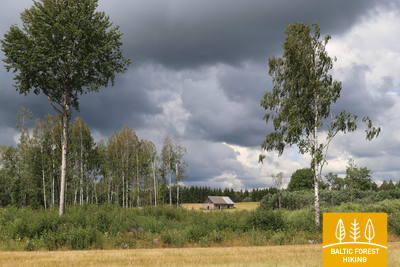
Matkarada läbib Alūksne kõrgustikku. See on üks raja raskemaid lõike, sest maastik on ebatasane ja künklik. Siin on palju liustiku sulamisel tekkinud orge ja künkaid, millelt avanevad avarad panoraamvaated ja kust võib näha isegi Eestit ja Suurt Munamäge. Kõige kaunimad vaated on siin kevadel, kui õitsevad võililled ja sügisel, kui värvuvad puude lehed. Kõrgematele küngastele rajati tuhanded aastad tagasi linnuseid, et õigeaegselt näha vaenlaste tulekut. Matkarada põikab korraks Eestisse, maaliliste metsajärvede ja vaatetorniga Paganamaale, et siis Läti kaudu piiripunkti viia.
Vaatamisväärsed kohad: Alūksne kõrgustiku maastik küngaste ja järvedega, Ape ajalooline keskus – dolomiithooned ja munakiviteed, Korneti-Peļļi ürgorg – Läti üks muljetavaldavamaid liustiku sulamisel tekkinud maastikke, Drusku linnamägi ja Dzērve mäe vaatetorn, Nõiakaljud Vaidava jõe kaldal.
 14. päev. Trapene‒Ape.
Apesse, kus Vaidava jõe kallastel elasid nõiad
Esimesed 6 km kulgevad maanteel P44, seejärel keerab matkarada põhja suunas Ādamsi–Ape teele. 4 km enne Riia-Pihkva maanteele jõudmist läbib metsa matkarada võimsa paksu metsa, mis on populaarne marja- ja seenemets. Pärast Riia-Pihkva maanteed kulgeb rada läbi põllumajandusmaastiku, ületab endise Ape-Valka kitsarööpmelise raudteetammi ning jõuab välja Ape, ühe Läti väikseima linna keskusesse.
 15. päev. Ape – Paganamaa – Korneti –Läti-Eesti piir.
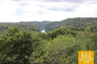
Läbi Korneti-Peļļi vagumuse ja Paganamaa
Pärast Apet kulgeb metsa matkarada künklikul põllumajandusmaastikul, siis siseneb pimedasse metsamassiivi, mida siin-seal ilmestavad sinised veesilmad. Peļļist edasi langeb metsa matkarada kokku Peļļi matkarajaga, ületab Eesti-Läti piiri ning lookleb 2 km ulatuses Eesti territooriumil, Paganamaal Liivajärve, Sarapuujärve ja Kikkajärve kallastel. Seejärel laskub rada Korneti-Peļļi liustikutekkelisse orgu. See on üks Läti kõige muljetavaldavamaid orge. Seejärel naaseb metsa matkarada Lätti ja viib üle künkliku maastiku kõrgele Drusku linnamäele. Päevateekond lõpeb Kornetis, kust on Eesti-Läti piirini veidi alla 3 km. Tee sinna viib mööda kaunitest Suur-Palkna (Lielais Baltiņš) ja Väike-Palkna (Mazais Baltiņš) järvedest. See osa teekonnast asub Veclaicene (Vana-Laitsna) maastikukaitsealal.