


Лесная тропа прибалтики - Gauja National Park

Национальный Парк Гауя
ДОЛИНА РЕКИ ГАУЯ – НАИБОЛЕЕ ВПЕЧАТЛЯЮЩАЯ РЕЧНАЯ ДОЛИНА В ЛАТВИИ
Рамкалны – Валмиера: 112 км, 4 - 8 день
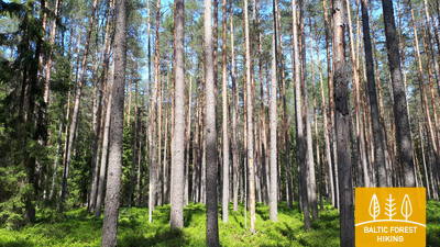
Лесная тропа Прибалтики проходит по долине реки Гауя, через весь национальный парк Гауя на протяжении более 100 км. На берегах реки Гауя много обнажений песчаника, которые создают красочные отражения в воде. Самые красивые виды открываются весной, когда цветет черемуха, а также осенью, когда листья деревьев окрашиваются в яркий красный и желтый цвет. Долина реки Гауя имеет выраженный рельеф – разница высот достигает 80 м. В основном путь лежит по лесным тропам вдоль реки, выходя из леса в Лигатне и Сигулде.
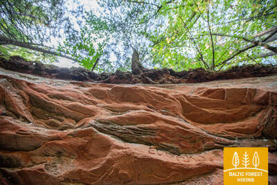
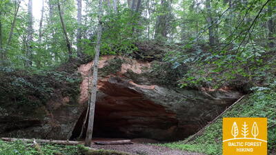
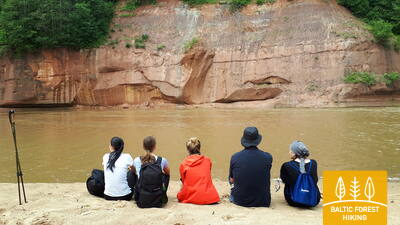
Наиболее яркие впечатления: Долина реки Гауя – наиболее глубокая речная долина в странах Балтии, Сигулда – одно из наиболее популярных туристических мест в Латвии, Бобслейная и саночная трасса “Сигулда”, Сигулдский воздушный трамвайчик на высоте 43 м, Средневековые замки Сигулды, Кримулды, Турайды и Цесисa, Пещера Гутманя, самый большой грот в Прибалтике, Природные тропыв Лигатне – возможность наблюдать за дикими животными и птицами, Поселок возле Лигатненской бумажной фабрики, Советский секретный бункер в Скальупес, Средневековый город в Цесисе, Скала возле пещеры Велнала, скала Кукю, скала Звартес, скалы Ергелю и Сиетиньиезис – наиболее впечатляющие обнажения песчаника девонского периода в Латвии, Валмиера – северные ворота национального парка Гауя.
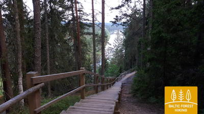
 4-й этап. Рамкални – Сигулда.
Красивейшие виды древнего русла Гауи возле Сигулды
Покинув парк Рамкални, Лесная тропа поднимается на высокий, крутой склон древней долины Гауи, проходит через поселок Гауя и устремляется вниз. Далее тропа пересекает речку Лорупе, проходит по изгибам Гауи и приводит к одному из самых впечатляющих береговых обнажений на Гауе – утесу Чертовой пещеры. Затем тропа ведет к таким достопримечательностям как Кейзарскатс, делает круг до Кейзаркреслса, Межакакиса на горе Какишкалнс, Сигулдской санно-бобслейной трассы и достигает центра Сигулды.
5-й этап. Сигулда – Лигатне.
В самом сердце Национального парка Гауя
Сделав круг через Сигулду, Лесная тропа по верхней части склона оврага Вейупите приводит путников к горе Парадизес, затем спускается по крутой лестнице к древней долине Гауи и оврагу Вейупите. Основную часть дальнейшего этапа составляют небольшие одинокие тропинки, ведущие через лес и луга (на которых в июне цветет смолка). Далее Лесная тропа пересекает ущелья многих небольших рек, на склонах которых виднеются обнажения песчаника. Последние шесть километров этапа – природные тропы Лигатне. На подступах к городу Лигатне Лесная тропа поднимается по склону древней долины Гауи, а в Лигатне спускается в глубокий овраг реки Лигатне, на склонах которого находится поселок бывшей бумажной фабрики.
 6-й этап. Лигатне – Цесис.
По старой цесисской дороге через долину реки Амата
Один из самых живописных участков Лесной тропы проходит через исторический поселок бумажной фабрики Лигатне, мимо геологического обнажения Сприньгю, по извилистым тропинкам Скальупе и Мифологической тропе. Заглянув в Советский бункер (один из секретных объектов периода Железного занавеса), Лесная тропа доходит до заповедника Рочу, пересекает реку Амата, по геологической тропе (самый красивый и скалистый участок у берегов Аматы) приводит к геологическому образованию Звартес. Далее Лесная тропа устремляется на высокий склон долины Аматы и по исторической дороге (ранее столбовая дорога Цесис – Рига, ныне небольшая проселочная и лесная дорога со старыми дорожными столбами) приводит в Ракши. Далее Тропа поднимается на холм Валюкалнс и из Озолкалнса идет по извилистым природным тропам Цирулиши, вдоль берегов Гауи, где находится множество родников и отложений песчаника. Этап завершается на улице Гауяс, по которой путешественники, преодолев 2,8 км, могут дойти до Старого города, провести день в Цесисе и продолжить путь.
7-й этап. Цесис – Цаунитес.
Впечатляющие обнажения песчаника на берегах Гауи
К базе водного туризма Ленчи Лесная тропа проходит по небольшим дорогам и тропам, пролегающим в лесу, вдоль излучины Гауи и древних речных долин. Не доходя до скал Эргелю, Лесная тропа сливается с выразительным рельефом местности, поднимается и спускается по склонам древней долины Гауи, изборожденной небольшими ручьями. Миновав скалы Эргелю, Лесная тропа слегка отклоняется в сторону Цесиса, в Пиешкални делает поворот в направлении Рамниеки, где пересекает мост через Гаую. Оставив позади базу водного туризма Яньрамис, Лесная тропа, будто стремясь оправдать свое название, устремляется в светлохвойный лес. Затем тропа приводит путников в Цаунитес, где находится одно из красивейших мест отдыха на берегах Гауи.
 8-й этап. Цаунитес – Валмиера.
По дороге в «Зеленый город» – Валмиеру
Покинув Цаунитес, Лесная тропа уводит в сосновые боры, смешанные леса, богатые мхом и травянистыми растениями, поднимается на склоны и холмы или огибает их. С утеса Сиетиньиезис открывается один из самых красивых видов на Гаую. Здесь же находится природная тропа Сиетиньиезис, которая заслуживает того, чтобы прогуляться по ней. Дальнейший путь, вплоть до границы Валмиеры, ведет через леса и мимо небольших хуторов. Миновав Валмиерскую окружную дорогу, Лесная тропа ведет по городским тротуарам Валмиеры. На завершающем участке, от «Железки» (бывший узкоколейный железнодорожный мост) до улицы Цесу, Лесная тропа ведет по небольшим тропам и обочинам, окруженным деревьями.