


Tропa Балтийского взморья - Curonian lagoon

Coastline of Curonian lagoon

Прибрежные пейзажи, рыбацкие деревни и Клайпеда
Венте – Древерна – Клайпеда: 50 км, 2 дня.
На мысе Венте находится орнитологическая станция с небольшим маяком, с которого видны воды Куршского залива. В прибрежных городах развивается туристическая инфраструктура, так как это популярное место для занятий виндсерфингом. Тропа Балтийского взморья проходит через Древерну, бывшую рыбацкую деревню с пристанью и кемпингом. Следующие 10 км тропа проходит по объекту промышленного наследия — каналу короля Вильгельма, построенному в 1860-х и 1870-х годах и названному в честь правившего тогда немецкого императора Вильгельма I. Из Клайпеды туристы могут сесть на паром до Куршской косы, где находится популярный Морской музей. и находится дельфинарий. Клайпеда (исторически называвшаяся Мемель) когда-то была частью Восточной Пруссии и поэтому находилась под влиянием немецкой культуры. Старый город Клайпеды уникален геометрической точностью планировки, все перекрестки проходят под прямым углом.
 72-й этап. Вянте – Древерна.
Восточное побережье Куршского залива (моря)
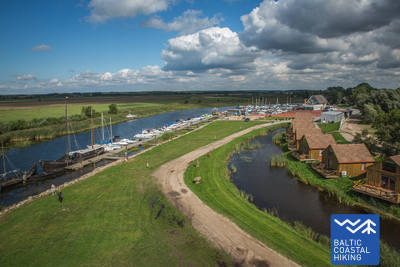
От мыса Вентес рагас Морская тропа по улице Марю (дорога № 2201) идет в направлении Клайпеды. Прибрежный пейзаж оживляют красочные постройки, обильно украшенные деревянными орнаментами. В некоторых из них оборудованы помещения для проживания и питания. Через 5 км Морская тропа поворачивает в сторону Куршского залива и маршрут продолжается по небольшой прибрежной тропе, окруженной влажными болотистыми лесами. Здесь оборудованы места для отдыха и смотровые площадки, с которых открываются прекрасные виды, можно увидеть находящиеся в 8–10 км песчаные дюны Куршской косы. Сделав крюк длиной около 3 км, Морская тропа возвращается на дорогу и примерно через 2 км достигает центра городка Кинтай, в котором стоит познакомиться с его архитектурным наследием. За Кинтай гравийная дорога длиной 5 км пересекает красивый, поросший соснами лесной массив дюн. За 3 км до деревни Древерна Морская тропа пересекает деревеньку Свянчеле, излюбленное место литовских энтузиастов кайтинга и парусного спорта. Здесь ведется строительство новых альтернативных туристических баз, кемпингов и мест общественного питания, а также развитие курорта. В деревне Древерна Морская тропа поворачивает на улицу Бангу. Здесь стоит сходить в порт Древерны, откуда можно снова полюбоваться прекрасной Куршской косой, расположенной на другом берегу Куршского залива.
 73-й этап. Древерна – Клайпеда.
Вдоль канала Короля Вильгельма в Клайпеду
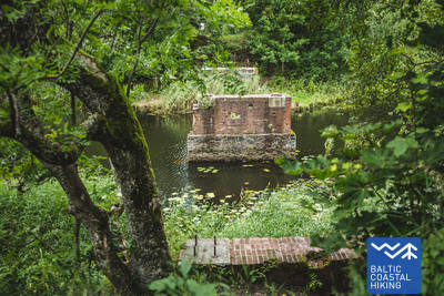
За деревней Древерна Морская тропа по дороге на Приекуле (№ 2206) пересекает реку Древерна, Клишупе и канал Короля Вильгельма, за которым она поворачивает налево и на протяжении 9 км петляет вдоль восточного берега исторического канала, вдоль усаженной деревьями аллеи. Здесь оборудованы места для отдыха и стенды с туристической информацией, рассказывающей о природном разнообразии местности. Еще через 4 км Морская тропа доходит до улицы Кайрю и, продолжая движение, Вы сможете полюбоваться городской средой. От проспекта Юрининку до проспекта Балтийос Морская тропа петляет по пешеходным дорожкам городских парков, пересекая парки Саюджио, Рейкьявико, Драугистес и другие. После пересечения проспекта Балтийос маршрут продолжается по пешеходным дорожкам и тротуарам проспекта Тайкос и через 3 км добирается до Биржевого моста.