


Miško takas - Veclaicene miškas

Veclaicene Forestland / Veclaicene miškas

GRAŽIAUSIOS ŠIAURĖS LATVIJOS AUKŠTYNĖS
Trapenė – Kornetis: 44 km, 14 – 15 diena
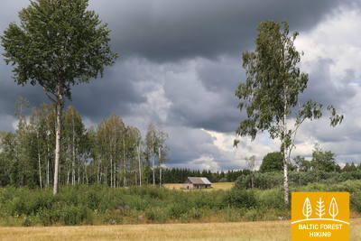
Virš Alūksnės kalvų driekiasi miško takas. Tai viena sunkiausių pėsčiųjų atkarpų, nes vietovė kalvota. Yra daugybė ledynų daubų ir kalvų, iš kurių atsiveria panoraminiai vaizdai iki pat Estijos ir Munamägi. Aukščiausios kalvos – tūkstantmečių istoriją turinčios pilių kalvos, kurios buvo tikslingai parinktos dėl aukštumos, kad bet kokios priešiškos kariuomenės būtų matomos toli. Šioje atkarpoje Miško takas sukasi per Paganama arba Velnio žemę Estijoje, kur žygeiviai ras apžvalgos bokštą su vaizdu į vaizdingus miško ežerus. Peizažai gražiausi pavasarį, kai žydi kiaulpienės, ir rudenį, kai raudonuoja lapai.
Akcentai: Alūksnės kalvų kraštovaizdžiai su kalvomis ir ežerais, Istorinis Apės centras – dolomito pastatai ir trinkelės, Kornetu – Peļļu subledyninė vaga – viena įspūdingiausių Latvijoje, Druskų piliakalnis ir Džervės kalno sargybos bokštas, Raganų skardžiai ant kranto. Vaidavos upė.
 Atkarpa 14. Trapene - Ape.
Į Apės miestelį, kur Vaidavos upės pakrantėje gyveno raganos
Pirmieji 6 kilometrai Miško tako veda P44, kol pasuka į šiaurę keliu Ādams–Ape. Likus 4 km iki Rygos–Pskovo greitkelio (A2), Miško takas eina per nuostabų, tankų mišką, kuris rudenį yra populiari vieta uogauti ir grybauti. Už magistralės Ryga–Pskovas Miško takas driekiasi žemės ūkio paskirties žemėmis, kol, kirsdamas buvusią siaurojo geležinkelio liniją Ape–Valka, pasiekia vieno mažiausių Latvijos miestelių Apės centrą.
 Atkarpa 15. Ape – Paganamaa – Korneti – Latvijos ir Estijos siena.
Per Korneti-Peļļi daubą ir Paganamaa arba "Velnio žemę"
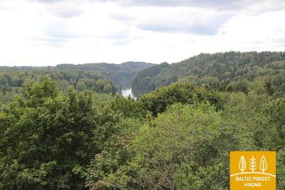
Išėjus iš Apės, Miško takas vingiuoja kalvotu dirbamos žemės kraštovaizdžiu, tada patenka į tamsų miško masyvą, retkarčiais pertraukiamą mėlynų ežerų paviršių. Už Pellių Miško takas eina tuo pačiu taku, kaip ir Pellių takas, kerta Latvijos/Estijos sieną ir vingiuoja Smilšāja, Sūneklio ir Ilgāja ežerų pakrantėmis 2 km Estijos pusėje, vadinama Paganamaa (vertimas: Velnio žemė). . Ten jis leidžiasi žemyn ir patenka į Korneti-Peļļi poledyninę įdubą, vieną įspūdingiausių Latvijos daubų. Miško takas grįžta į Latviją ties Ilgājs ir, stačiai pakilęs, kalvota vietovė nukelia į Druskų piliakalnį. Miško takas leidžiasi į Korneti. Jis yra mažiau nei 3 km nuo Korneti centro iki Latvijos ir Estijos sienos. Maršruto metu atsiveria gražūs kraštovaizdžiai Didžiojo Baltinio ir Mažojo Baltinio ežerų pakrantėse. Ruožas yra saugomo kraštovaizdžio vietovėje „Veclaicene“.