


Miško takas - Kaunas

Kaunas ir Kauno rajonas
Vaizdingi miesteliai žalumos apsuptyje ir tarpukario architektūra dviejų upių santakoje
Pakuonis – Kaunas – Lampėdis – Kulautuva – Vilkija: 79 km, 5 dienų.
Vienas gražiausių Lietuvos miestų – Kaunas, įsikūręs Nemuno ir Neries santakoje. Tai antras pagal dydį Lietuvos miestas, Rusijos imperijos laikais buvusi Kauno gubernijos sostinė (1842 – 1915), o 1919 – 1940 metais – laikinoji Lietuvos Respublikos sostinė. Panemunės šilas yra didžiausias Kauno parkas su paplūdimiais ant Nemuno kranto, dviračių takais ir pasivaikščiojimo vietomis. 125 ha ploto Lampėdžio karjeras buvo suformuotas buvusio žvyro karjero vietoje. Jo pakrantėse yra miestiečių pamėgtos poilsio ir maudymosi vietos. Nemuno pakrante, užsukdamas į kurortinį Kulautuvos miestelį, vingiuoja pėsčiųjų ir dviračių takas, nuo kurio atsiveria vaizdingi upės peizažai. Keliaujant iki Vilkijos miesto, smagu mėgautis besikeičiančiu kraštovaizdžiu su nedidelėmis gyvenvietėmis, piliakalniais ir miškais.
 Atkarpa 62. Pakuonis – Vaišvydava.
Kauno marių regioniniu parku
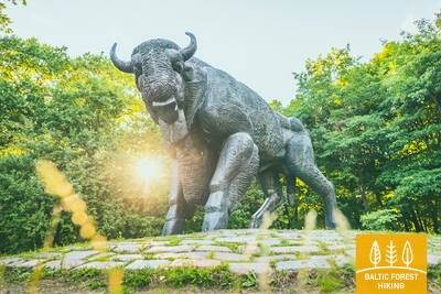
Iš Pakuonio miestelio Miško takas tęsiasi Kauno gatve (Nr. 1901) šiaurės vakarų, šiaurės kryptimi ir po 7 km pasiekia Piliuonos miestelį. Keliautojus pasitinka pavienės sodybos su aplink plytinčiais dirbamais laukais ir sodais. Už Piliuonos kelias vingiuoja Nemuno gatve ir po 1,6 km pasuka į kairę link Dubravų. Praėjus miško masyvą, kuriame vasarą ir rudenį galima rasti vertingų grybų ir uogų, po maždaug 2,4 km Miško takas išveda prie Dubravų kaimo, vinguriuoja pagrindine gatve ir po 3 km (Klonio gatvė, Nr. 1937) pasiekia Vaišvydavos miestelį, kuriame yra Kauno marių regioninio parko lankytojų centras ir aplink išsidėstę unikalūs gamtos objektai: rezervatinė apyrubė, arboretumas.
Atkarpa 63. Vaišvydava – Kaunas.
Kauno parkais
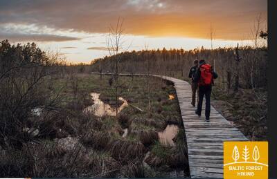
Nuo Kauno marių direkcijos lankytojų centro Miško takas veda link Rokų miško ir Miškininkų, Kelmyno, Muraškinės, Žarstos, Garšvės ir Rokelių gatvėmis apsuka nemažą ratą aplink Kauno pietryčių dalies priemiesčius, pasiekia Kauno miestą, kerta Marijampolės kelią (Nr. 139) ir Balčkalnio gatve šiaurės kryptimi leidžiasi link Panemunės mikrorajono. Prie Kauno technologijos universiteto Inžinerijos licėjaus stadiono Miško takas nusileidžia iki Vaidoto gatvės, šaligatviu toliau keliauja iki Baterijos plento, kur pasuka į kairę link Panemunės šilo. Apie trečdalį Kauno miesto ploto užima parkai ir kitos gamtinės teritorijos. Miško takas keliauja miestu per žaliausius jo plotus. Apie 2,5 km jis vinguriuoja per Panemunės šilą, kuriame gausu poilsio vietų ir yra net paplūdimys. Toliau Trijų mergelių tiltu Miško takas kerta Nemuną, veda per Gričiupio rajoną, suka palei Kauno zoologijos sodą, driekiasi Kauno Ąžuolynu ir už Lietuvos sporto universiteto pasiekia Vytauto parką, kurio laiptais nusileidžia iki Laisvės alėjos pradžios ir tęsiasi iki Nepriklausomybės aikštės su įspūdinga Įgulos bažnyčia viduryje bei jaukiomis kavinukėmis aplink.
SVARBU. Kauno miestą kertančiose atkarpose žymėjimų nėra.
Atkarpa 64. Kaunas – Lampėdžiai.
Istorinėmis Kauno miesto gatvėmis
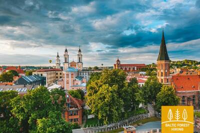
Kaunas - antras pagal dydį Lietuvos miestas, Laikinoji sostinė 1919 - 1940 m. ir 2022 metų Europos kultūros sostinė. Miško takas tęsiasi garsiausia miesto gatve, skirta tik pėstiesiems ir dviratininkams - liepomis apsodinta Laisvės alėja. Daugiau kaip 1,5 km ilgio alėja ir aplinkinės gatvės išsiskiria unikalia modernizmo architektūra – 1914–1940 m. statytiems namams suteiktas Europos kultūros paveldo ženklas. Toliau maršrutas atveda į Vilniaus gatvę - pagrindinę viduramžiško Kauno, kuriame šeimininkavo Hanzos pirkliai, gatvę. Senamiestyje Miško takas vingiuoja pro Rotušės aikštę, įvairius istorinius pastatus ir bažnyčias, kol Nemuno pakrante pasiekia didžiausių Lietuvos upių Nemuno ir Neries santakos vietą ir čia esantį parką. Praėjus Kauno pilį, tiltu perėjus į kitą Neries upės pusę, Miško takas pėsčiųjų ir dviračių takais toliau tęsiasi dar 4 km iki buvusio Lampėdžių žvyro karjero, kuris yra užpildytas vandeniu, čia įrengtas paplūdimys ir kempingas, todėl šiltuoju sezonu tampa mėgstama kauniečių poilsio vieta.
SVARBU. Kauno miestą kertančiose atkarpose žymėjimų nėra.
Atkarpa 65. Lampėdžiai – Kulautuva.
Nemuno pakrantėmis
Pirmuosius 2 km laukiniu takeliu Miško takas vinguriuoja šiaurine Lampėdžių karjero pakrante ir priešais kapines išveda į automobilių kelią. Šaligatviu tęsdamas savo kelionę Raundondvario kryptimi, Miško takas po 1,7 km kerta Nevėžio upę Kazio Veverskio tiltu. Po 0,6 km Miško takas pasuka kairėn į Pakalnės gatvę ir priešais Nevėžio ir Nemuno santakos vietą mažais takeliais toliau vingiuoja dešiniąja Nemuno pakrante. Nemuno slėnio pakrantėse matomos senų piliakalnių vietos. Už Šilelio kaimo Miško takas tęsiasi pėsčiųjų ir dviračių takais iki kurortinio Kulautuvos miestelio, prieš kurį daro lanką nedideliu miško keliuku ir Pušyno bei V. Augustausko gatvėmis pasiekia galutinį šios atkarpos tašką.
SVARBU. Kauno miestą kertančiose atkarpose žymėjimų nėra.
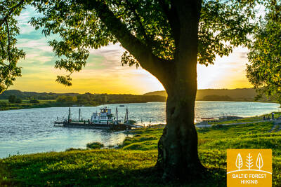
Atkarpa 66. Kulautuva – Vilkija.
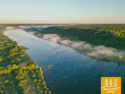
Nemuno užliejamomis pievomis
Visos šios atkarpos metu Miško takas veda takeliais ir nedideliais kaimo žvyrkeliais dešiniuoju Nemuno upės krantu. Maršrutas driekiasi gražiais kraštovaizdžiais, pakrantės pievomis ir jaukiomis gyvenvietėmis, nuo kurių atsiveria vaizdai į upę. Šios Miško tako atkarpos galutinis taškas – Vilkijos perkėla – jau iš tolo matoma Nemuno pakrantės linkyje. Priešais perkėlą yra Vilkijos miesto centras. Vilkija - tai savitas kalnų miestas, urbanistikos paminklas, kurio unikaliam pavidalui ir raidai įtakos turėjo geografinė padėtis ir gamtinės sąlygos, o ypač – Nemuno upės vanduo. Antroje vasaros pusėje Nemuno pievos skęsta geltonuose ir mėlynuose žieduose. Upiniu motoriniu keltu „Vilkija“ verta persikelti į kitą Nemuno pusę ir grįžti atgal, nes tokia transporto priemonė Baltijos šalyse yra išsaugota vos keliose vietose.