


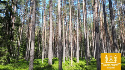
Miško takas - Gaujos NP

Gaujos nacionalinis parkas

GAUJOS SLĖNIS – ĮSPŪDINGIAUSIAS SENOVĖS UPĖS SLĖNIS LATVIJOJE
Rāmkalni – Valmiera: 112 km, 4 – 8 diena
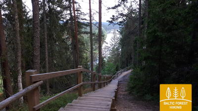
Apie 100 km Miško takas driekiasi per Gaujos upės senslėnį ir Gaujos nacionalinį parką. Gaujos upės pakrantėse matyti spalvingos smiltainio atodangos, kurios atsispindi vandenyje. Vaizdai nuostabiausi pavasarį, kai žydi paukščių vyšnios, ir rudenį, kai medžiai tampa raudoni ir geltoni. Gaujos senslėnis pasižymi savitu reljefo reljefu, kuris gali svyruoti iki 80 m. Didžiausia kelio dalis veda miško takais, palei upę ir išvažiuoja iš Līgatnės ir Siguldos miškų.
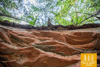
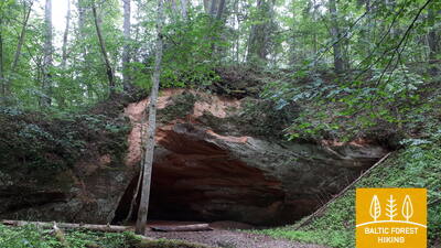
Svarbiausi objektai: Gaujos senslėnis – giliausias upės slėnis Baltijos šalyse, Sigulda – viena iš populiariausių turistinių vietų Latvijoje, Bobslėjaus ir rogučių trasa Sigulda, Siguldos funikulieriai virš Gaujos 43 m aukštyje, Viduramžių Siguldos, Krimuldos, Turaidos ir Cėsių pilys, Gūtmanala urvas, didžiausia Baltijos šalyse grota, Līgatnės gamtos takai suteikia galimybę stebėti vietinę gamtą ir paukščius, Līgatnės popieriaus fabriko kaimas – pramonės paveldas, Slaptas sovietinis bunkeris Skaļupes, viduramžių senoji vieta. Cėsių miestas, Velnio urvo skardis, Kūķu uola, Žvartės uola, Ērģeļu uolos ir Sietiņiezis – įspūdingiausios devono smiltainio atodangos Latvijoje, Valmiera – šiauriniai vartai į Gaujos nacionalinį parką.
 Atkarpa 4. Rāmkalni - Sigulda.
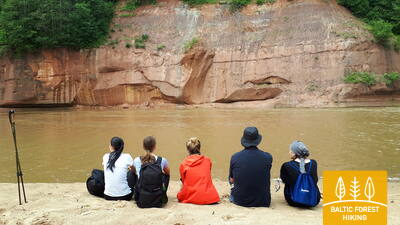
Nuostabus Gaujos upės slėnio kraštovaizdis netoli Siguldos
Pro „Rāmkalni“ Miško takas klaidžioja stačiais Gaujos slėnio krantais, eina pro Gaujos kaimą ir grįžta žemyn. Tada jis kerta Lorupės upę ir tęsiasi Gaujos vingiais, aplenkdamas vieną įspūdingiausių upės atodangų Velnalos uolas, kyla į Ķeizarskats apžvalgos aikštelę ir skrieja žemyn iki Ķeizarkrēsls, nuotykių parko „Mežakaķis“ prie Kaķīškalno ir Siguldos bobslėjaus ir rogučių trasa.
Atkarpa 5. Sigulda - Līgatne.
Gaujos nacionalinio parko širdyje
Pravažiavus Siguldą, Miško takas Vējupīte eina iki Paradīzes piliakalnio, kur statūs laiptai leidžiasi žemyn į Gaujos upės senslėnį ir Vējupytės daubą. Jis ir toliau vingiuoja mažesniais takeliais per pievas, kerta mažas upes, kurių krantuose atsiskleidžia smiltainio atodangos. Paskutiniai šeši kilometrai šios atkarpos eina mažesniu takeliu žemyn Līgatnės gamtos takais. Artėjant prie Līgatnės Miško takas pakyla į Gaujos slėnio kalvas, o paskui vėl leidžiasi žemyn į gilią Līgatnės upės daubą, kur yra buvęs Līgatnės popieriaus fabriko kaimas.
 Atkarpa 6. Līgatne - Cēsis.
Senuoju Cėsių keliu per Amatos upės slėnį
Viena vaizdingiausių Miško tako dalių driekiasi palei istorinį Līgatnės popieriaus fabriko kaimą, kerta Spriņģi uolą, vingiuoja palei Skalupės ir Mitologinį taką, sustoja vienoje slapčiausių vietų šioje Geležinės uždangos pusėje, Sovietinis bunkeris, toliau tęsiasi palei Roči gamtos rezervatą, kerta Amatą (gražiausia ir uoliausia upės dalis) ir galiausiai patenka į Zvārtes uolą. Toliau Miško takas driekiasi aukštais Amatos slėnio krantais ir eina istoriniu Cėsių–Rygos „greitkeliu“ (dabar nedidelis kaimo/miško keliukas su senais mylių stulpais) iki Rakšų, tada kyla į Vāļukalni kalvas ir Ozolkalns, eidami palei Gaujos upė iki Cīrulšių gamtos takų. Jis sustoja prie Gaujos gatvės, tačiau keliautojai taku gali tęstis dar 2,8 km iki Cėsių, ten pernakvoti ir kitą dieną toliau eiti.
Atkarpa 7. Cēsis - Caunītes.
Įspūdingos smiltainio atodangos Gaujos upės pakrantėje
Miško takas eina mažais keliukais ir takeliais per mišką iki pat vandens turistų stovyklavietės „Lenči“, vingiuoja vis kitokiu reljefu pro Ērgeļu skardžius ir patenka į Gaujos upės senslėnį. Pravažiavus Ērgeļu skardžius, takas pasuka atgal link Cėsių, bet tada nusuka į Pieškalnyje esančią Rāmnieki pusę, kirsdamas upę. Po vandens turistinės stovyklos „Jāņarāmis“ Miško takas patenka į gražų, šviesų pušyną, eina per mišką, kol pasiekia „Caunītes“, kuri yra viena gražiausių vietų Gaujos upės pakrantėje.
 Atkarpa 8. Caunītes - Valmiera.
Pakeliui į Valmierą – „Žaliąjį miestą“
Iš Caunites Miško takas veda per kerinčius pušynus ir pelkes, skersai ir aplink kalvas bei šlaitus. Iš Sietiņiezio atsiveria vienas gražiausių vaizdų į Gaują, todėl galbūt verta skirti šiek tiek daugiau laiko Sietiņiezio pažintiniam takui. Tolesnis kelias driekiasi sodybomis ir miškais, kol pasieksite Valmierą. Už Valmieros aplinkkelio Miško takas veda miesto šaligatviais, o paskutinė kelio atkarpa – nuo vadinamojo „Dzelzītio“ (siauro geležinkelio tilto) iki Cėsų gatvės – eina miškingu taku palei Gaują.