


Baltischer Küstenwanderweg - Curonian lagoon

Coastline of Curonian lagoon

Küstenlandschaften, Fischerdörfer und Klaipėda
Ventė – Dreverna – Klaipeda: 50 km, 2 Tage.
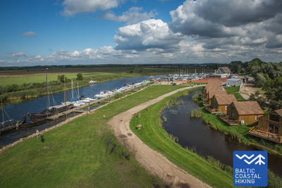
Am Kap Ventė befindet sich eine ornithologische Station mit einem kleinen Leuchtturm, von dem aus man das Wasser des Kurischen Haffs sehen kann. Die touristische Infrastruktur entwickelt sich in den Küstenstädten, da dies ein beliebter Ort zum Windsurfen ist. Der Ostseeküstenwanderweg schlängelt sich durch Dreverna, ein ehemaliges Fischerdorf mit Jachthafen und Campingplatz. Auf den nächsten 10 km folgt der Weg einem Industriedenkmal – dem König-Wilhelm-Kanal, der in den 1860er und 1870er Jahren erbaut und zu Ehren des damals regierenden deutschen Kaisers Wilhelm I. benannt wurde. Von Klaipėda aus können Wanderer eine Fähre zur Kurischen Nehrung nehmen, wo sich das beliebte Meeresmuseum befindet und Delfinarium befindet. Klaipėda (historisch Memel genannt) gehörte einst zu Ostpreußen und wurde somit von der deutschen Kultur beeinflusst. Die Altstadt von Klaipėda ist einzigartig mit der geometrischen Präzision ihrer Planung, bei der alle Kreuzungen perfekte rechte Winkel bilden.
 72. Etappe. Ventė (dt. Windenburg) – Dreverna.
Am östlichen Ufer des Kurischen Haffs
Ab Ventės ragas (dt. Windenburger Kap) führt der Meeresweg (lt. Jūrų takas) auf der Marių-Straße (Straße Nr. 2201) in Richtung Klaipėda. Die Küstenlandschaft wird von farbenfrohen Gebäuden, die reich mit Holzornamenten geschmückt sind, belebt. Einige verfügen über Unterkünfte und Verpflegungsmöglichkeiten. Nach 5 km biegt der Meeresweg zum Kurischen Haff ab und führt auf einem kleinen Küstenpfad, umgeben von feuchten Sumpfwäldern weiter. Hier findet man Erholungsplätze und Aussichtstürme, von denen öffnen sich die schönsten Landschaften der Sanddünen von der Kurischen Nehrung, die in einer Entfernung von 8–10 km liegen. Nach einem Bogen von etwa 3 km führt der Meeresweg zur vorherigen Straße und nach etwa 2 km erreicht er das Zentrum des Ortes Kintai, dessen es wert ist, das architektonische Erbe kennenzulernen. Hinter Kintai führt eine 5 km lange Schotterstraße durch ein wunderschönes, mit Kiefern bewaldetes Dünenmassiv. 3 km vom Dorf Dreverna, überquert der Meeresweg das Flüsschen Svencelė, das ein beliebter Ort für litauische Segler und Kitesurfern/Kiteboarden ist. Der Bau von neuen, alternativen Touristenstützpunkten, Camping- und Gastronomieplätzen, sowie Entwicklungen von Kurorte sind hier im Gange. Im Dorf Dreverna biegt der Meeresweg in die Bangų Straße ab. Hier lohnt sich ein Spaziergang bis zum Hafen von Dreverna vorzunehmen und noch einmal einen Blick über das Kurischen Haff auf die wunderschöne Kurische Nehrung zu werfen.
 73. Etappe. Dreverna – Klaipėda (dt. Memel).
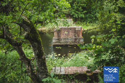
Entlang an dem König-Wilhelm-Kanal nach Klaipėda
Hinter dem Dorf Dreverna überquert der Meeresweg (lt. Jūrų takas) auf der Priekulė-Straße (Nr. 2206) den Fluss Dreverna, Klišupė und den König-Wilhelm-Kanal, danach biegt er nach links und schlängelt sich am Ostufer 9 km des historischen Kanals entlang wie in einer, von den Blätter der Bäume gesäumten Allee. Es gibt hier genügend Plätze zum Erholen und Ausruhen, sowie Touristeninformationsstände, die über Vielfalt der Natur in der Umgebung unterrichten. Nach weiteren 4 km erreicht der Meeresweg die Straße Kairių dessen Fortbewegung entlang, erlaubt einen Blick auf die Schönheit des Städtchens. Von der Avenue Jūrininkų bis zur Baltijos führt der Meeresweg durch die Fußgängerwege des Stadtparks Sąjūdis, Reykjavik, Draugystės und anderer Parks. Die Route überquert dann Avenue Baltijos und führt auf den Fußgänger- und Gehwegen der Taikos Avenue bis zur 3 km entfernten "Biržos tiltas" (dt. Brücke der Börse) weiter.