


Baltischer Küstenwanderweg - Seaside resorts

Seaside resorts

Sandstrände und lichtdurchflutete Pinienwälder
Klaipėda – Palanga – Litauisch-lettische Grenze: 48 km, 2 oder 3 Tage.
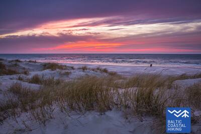
Klaipėda und Palanga sind beliebte Küstenstädte mit der Atmosphäre eines Badeortes: mit Tavernen, Hotels, Straßencafés und Musikern. Klaipėda ist die einzige Hafenstadt und die drittgrößte Stadt Litauens. Die Stadt Šventoji an der Küste, wo der Fluss Šventoji in die Ostsee mündet, ist ebenfalls ein beliebter Ferienort. Zwischen Šventoji und Palanga führt der Baltische Küstenwanderweg durch den Küstenregionalpark. Der Park wurde gegründet, um die Küsten- und Meereslandschaft, die Biodiversität und das lokale Kulturerbe zu schützen. Die bekannteste Touristenattraktion an der Küste ist die Holländermütze, eine über 20 m hohe Steilküste, die einst Seefahrern und Fischern als Seezeichen diente. Zu den historischen Stätten im Park gehören authentische Gehöfte sowie Küstenverteidigungsbatterien der deutschen Armee aus dem Zweiten Weltkrieg.
 67. Etappe. Klaipėda (dt. Memel) – Palanga (dt. Polangen).
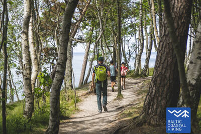
Durch den Regionalpark der Küste
Zuerst führt der Meeresweg (lt. Jūrų takas) der H. Manto Straße, durch das Zentrum der Stadt Klaipėda entlang, dann überquert er den Erholungspark und die Eisenbahn und an der Südseite der Siedlung Melnragė bevor er wieder an der Küste der Ostsee ankommt. Danach führt er weiter an der Strandpromenade und den schmalen, die Dünen schützenden Holzpfaden (Knüppelpfad) vorbei und erstreckt sich dann auf einem gemütlichen Weg, der ca. 10–20 m vom Wander- / Radweg entfernt durch die Wälder der Küste verläuft und die Zweite Melnragė hinter sich lässt - bis die Siedlung Giruliai erreicht ist. In der Nähe von Giruliai bevorzugt er für einen kurzen Augenblick den Genuss eines Strandes, dann führt er vom Ort Kukuliškės bis südlich von Karklė und anschließend dem sehr schönen Ufer des ehemaligen Litorina-Meeres, das mit unberührtem Wald bewachsen ist. Weiter verläuft er neben der malerischen, von den Wellen durchfluteten Klippe mit mehreren Aufsichtsplattformen inkl. den "Olando kepurė" (dt. Hut/ Mütze des Holländers ) in Richtung Karklė. Folgende 11 km von der Siedlung Karkle bis zum Botanischen Park verläuft der Meeresweg an sandigen Kiesstränden mit ihren wunderschönen großen Steinen. Dem Pfad im westlichen Teil des botanischen Parks folgend, erreicht der Meeresweg die "Meilės Alėja" (dt. Allee der Liebe) und führt zur Fußgängerbrücke von Palanga. Ein Großteil dieser Strecke passiert den Regionalen Park der Küstenregion (lt.Pajūrio regioninis parkas).
 68. Etappe. Palanga (dt. Polangen)– litauisch-lettische Grenze (Šventoji) (dt. Heiligenau).
Durch die beliebtesten Küstenkurorte Litauens
Nachdem der Meeresweg (lt. Jūrų takas) über eine Brücke das Flüsschen Rąžė überquert hat, schlängelt er sich weiter, der Fußgänger- / Joggingpfad "Labrytys" entlang und führt zum Meer in der Nähe der Kontininkų-Straße. Abwechslungsreich geht er dann 9 km am sandigen, vom Meer umgespültem Strand weiter bis zur alten Mole des Städtchen Šventoji, entlang. Anschließend windet er sich um die Mündung des Flusses Šventoji, führt durch das Kurort-Städtchen, am Ende der Kopų-Straße überquert er den Fluss mit einer Fußgänger - Hängebrücke und lotst wieder zum Strand hinaus. Der Meeresweg macht noch einmal einen kleinen Bogen in der Nähe des Heiligtums "Žemaičių Alka" um dann am Sandstrand entlang nach 3 km die litauisch-lettische Grenze zu erreichen.